
If you’re looking for the best handheld GPS devices for hiking in 2025, I recommend choosing models with multi-band GNSS support like GPS, GLONASS, and Galileo for accurate navigation in tough terrains. Durability and long battery life are vital, so look for waterproof and rugged designs that last several days. Devices with satellite communication, like the Garmin inReach Mini 2, boost safety in remote spots. Keep exploring, and I’ll share more details to help you pick the perfect device.
Key Takeaways
- Look for devices with multi-band GNSS support and satellite communication for high accuracy and connectivity in remote areas.
- Prioritize rugged, waterproof models with long battery life to withstand tough outdoor conditions and multi-day hikes.
- Choose handheld GPS units with detailed offline maps, external map support, and user-friendly interfaces for effective navigation.
- Consider safety features like SOS alerts, two-way messaging, and real-time location sharing for outdoor safety.
- Ensure compatibility with apps and map updates to keep navigation data current and customize trip planning.
A6 Handheld GPS for Hiking

If you’re serious about outdoor adventures and need reliable navigation, the A6 Handheld GPS is an excellent choice. It supports four satellite systems—GPS, GLONASS, BEIDOU, and QZSS—delivering high accuracy within 5 feet. Its 2.4-inch sunlight-readable color display remains visible at night, and the non-slip, button-operated design is easy to use. With 1,000 waypoint capacity and features like route tracking and back navigation, it’s perfect for hiking, camping, or hunting. Rugged, waterproof (IP65), lightweight, and compact, it’s built to withstand tough conditions. Plus, its long-lasting 20-hour battery guarantees you stay powered through your entire adventure.
Best For: outdoor enthusiasts who need a rugged, high-accuracy GPS device for hiking, camping, hunting, or backpacking adventures.
Pros:
- Supports four satellite systems (GPS, GLONASS, BEIDOU, QZSS) for precise positioning within 5 feet.
- Long-lasting 20-hour battery and multiple charging options ensure reliable power during extended outdoor activities.
- Waterproof (IP65 rated), durable, and lightweight, suitable for tough outdoor conditions.
Cons:
- Limited menu system and clumsy navigation interface can be frustrating to use.
- No map functionality or UTM coordinate support, restricting some navigation features.
- Loud beeping on button presses and inability to silence volume may be annoying for some users.
2 Packs GPS Handheld for Hiking with Tracking and Communication

For outdoor enthusiasts who need reliable group tracking and communication without relying on cellular networks, handheld GPS devices like the Gotele Xquad 03 are an excellent choice. These rugged units support private, closed-group networks for up to 15 members, with a range of about three miles. They feature real-time positioning, safe zone alerts, and compass calibration, making them perfect for activities like hiking, camping, or hunting. Each device doubles as a watch, offers up to two days of battery life, and is built to withstand tough weather. While hardware is solid, software usability can be challenging, and app support varies, so some patience is necessary.
Best For: outdoor adventurers seeking reliable, offline group tracking and communication for activities like hiking, hunting, and camping in rugged environments.
Pros:
- Supports private, closed-group network for up to 15 members with real-time location sharing
- Durable, weatherproof design suitable for tough outdoor conditions
- Features like safe zone alerts, compass calibration, and dual-purpose as a watch
Cons:
- Software and app usability issues, including limited guidance and inconsistent performance across platforms
- Firmware updates often reset settings, adding hassle to device management
- Limited display readability in bright sunlight and minimal instructions for navigation or waypoint creation
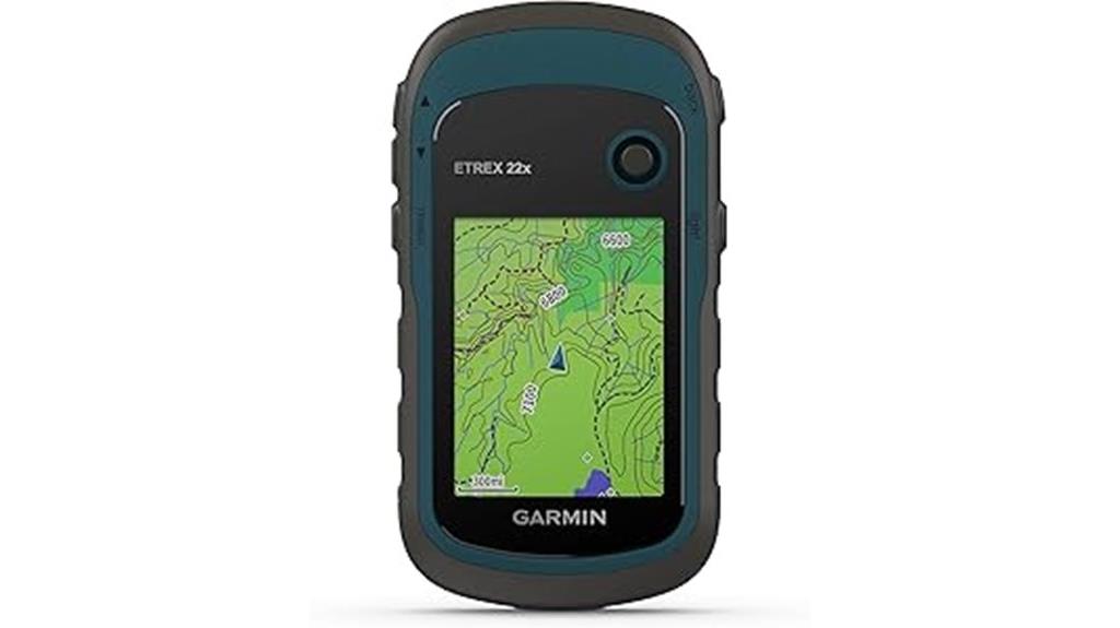
The Garmin eTrex 22x stands out as an excellent choice for outdoor enthusiasts who need a rugged, reliable GPS device that can handle challenging environments. Weighing just 5 ounces and featuring a compact design, it’s easy to carry on any adventure. Its sunlight-readable 2.2-inch color display offers clear visibility even in bright sunlight. With preloaded Topo Active maps and dual GPS/GLONASS support, it performs well in dense forests and remote areas. Durable and waterproof with 8 GB of storage, it runs on AA batteries for up to 25 hours. Perfect for hiking, biking, or land surveying, it’s a dependable tool in tough conditions.
Best For: outdoor enthusiasts, hikers, and land surveyors seeking a rugged, reliable GPS device for challenging environments.
Pros:
- Durable, waterproof design suitable for harsh outdoor conditions
- Long battery life of up to 25 hours with AA batteries
- Supports dual GPS and GLONASS satellite systems for improved signal reception in dense areas
Cons:
- Small 2.2-inch screen may limit detailed map viewing and visibility in bright sunlight
- Lacks modern connectivity features such as Bluetooth or Wi-Fi for wireless updates and data transfer
- Uses an outdated miniUSB port, which may complicate connections and updates
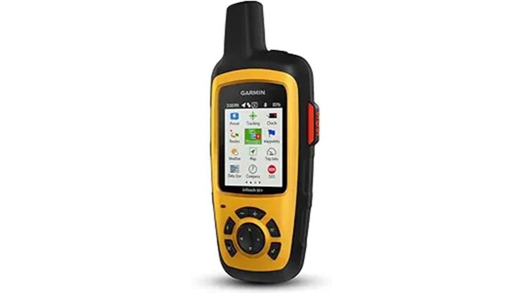
Garmin inReach Mini 2 Satellite Communicator

The Garmin inReach Mini 2 Satellite Communicator stands out as an essential tool for adventurers venturing into remote areas where mobile signals are unavailable. Its compact, lightweight design — just 3.5 ounces — makes it easy to carry on any outdoor trip. The device offers reliable global two-way messaging, interactive SOS, and real-time location sharing via MapShare. Its durable, water-resistant casing ensures durability in tough conditions. With up to 14 days of battery life and features like a digital compass and TracBack routing, it keeps you connected and safe. Despite some setup delays and message transmission times, the Mini 2 is a trusted companion for remote adventures.
Best For: outdoor enthusiasts and adventurers who need reliable communication and safety features in remote areas without cellular coverage.
Pros:
- Compact, lightweight design weighing only 3.5 ounces for easy portability
- Reliable global two-way messaging and interactive SOS for safety
- Long battery life of up to 14 days in tracking mode ensures extended use in remote environments
Cons:
- Slow message transmission and occasional delays in receiving replies
- Setup can be complex with vague instructions, leading to longer activation times
- Limited mapping features, showing only waypoints and current location without detailed onboard maps
Garmin 010-00970-00 eTrex 10 Worldwide Handheld GPS Navigator
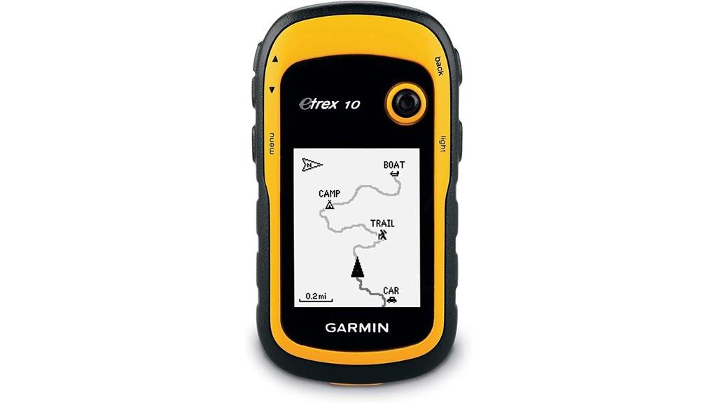
If you’re looking for a reliable, budget-friendly GPS device that can handle rugged outdoor conditions, the Garmin eTrex 10 is an excellent choice. Its tough, waterproof design and high-sensitivity GPS with WAAS, HotFix, and GLONASS support guarantee accurate positioning in challenging environments. The device features a clear 2.2-inch monochrome screen readable in sunlight and rain, though it’s prone to scratches. With over 20 hours of battery life using AA batteries, it supports waypoint, track, and geocache management but lacks detailed maps and turn-by-turn directions. It’s perfect for basic navigation and outdoor adventures on a budget.
Best For: Outdoor enthusiasts seeking a rugged, budget-friendly GPS device for basic navigation in challenging environments without the need for detailed maps or turn-by-turn directions.
Pros:
- Rugged, waterproof design withstands harsh outdoor conditions
- High-sensitivity GPS with WAAS, HotFix, and GLONASS for accurate positioning
- Long battery life of over 20 hours using AA batteries
Cons:
- No color or detailed maps, limiting navigation options
- Lacks a touchscreen and digital compass, reducing ease of use
- Screen surface is prone to scratches, requiring a protective cover
Garmin GPSMAP 65 Handheld GPS with Expanded Satellite Support
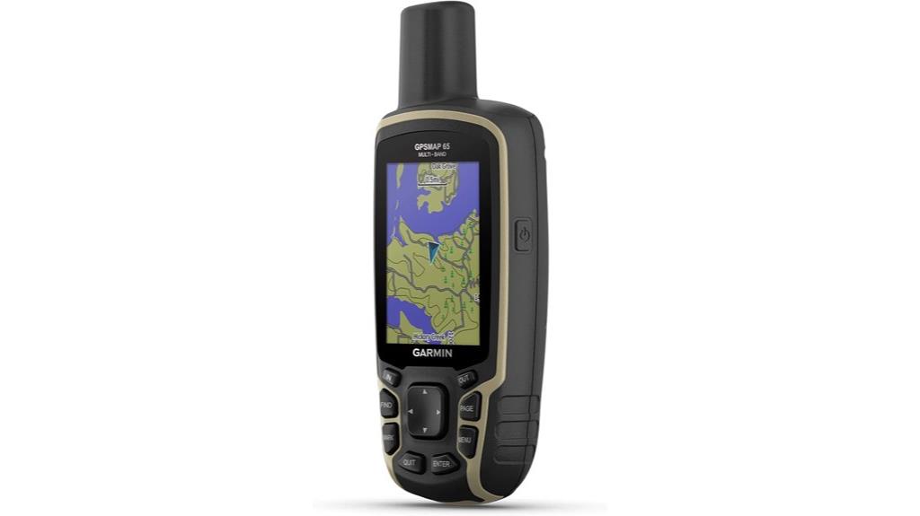
For hikers who need reliable navigation in challenging environments, the Garmin GPSMAP 65 stands out thanks to its expanded satellite support. It features a rugged design with a 2.6-inch color display, built for outdoor durability, and includes preloaded TopoActive and public land maps. Its multi-band GNSS support—GPS, GLONASS, Galileo, and QZSS—delivers exceptional accuracy, even in dense forests or steep terrain. The device supports wireless connectivity, allowing you to manage routes via the Garmin Explore app. Powered by two AA batteries, it offers flexible, extended use. Its physical buttons ensure easy operation in bad weather or with gloves, making it a dependable hiking companion.
Best For: outdoor enthusiasts and hikers who require precise, reliable navigation in challenging environments like dense forests and steep terrains.
Pros:
- Expanded multi-band GNSS support (GPS, GLONASS, Galileo, QZSS) offers high accuracy even in difficult conditions
- Rugged, weather-resistant design with a clear, sunlight-readable 2.6-inch color display
- Use of replaceable AA batteries for extended, flexible power options in the field
Cons:
- Outdated user interface and complex map management software can be cumbersome to navigate
- Firmware updates and map loading may be slow and occasionally unstable or crash-prone
- Regional map coverage limitations may require additional purchases for full international use
Spot X with Bluetooth 2-Way Satellite Messenger

When I need reliable emergency communication in remote outdoor areas, the Spot X with Bluetooth 2-Way Satellite Messenger stands out as a solid choice. It offers SOS protection, GPS tracking, and messaging via the Globalstar satellite network, supporting Bluetooth and USB connections. The device has a rugged 2.9-inch display, weighs only 7 ounces, and features a long-lasting battery suited for outdoor use. It functions independently with its own US mobile number for messaging, making it perfect for hiking, camping, or travel in areas without cellphone coverage. While indoor signal can be limited, its durability and emergency features make it a dependable safety tool for off-grid adventures.
Best For: outdoor enthusiasts and travelers who need reliable emergency communication and GPS tracking in remote areas without cellphone coverage.
Pros:
- Durable rugged design suitable for harsh outdoor conditions
- Long battery life ideal for extended trips
- Independent messaging with its own US mobile number for basic communication
Cons:
- Limited message capacity and no full two-way messaging like some competitors
- Indoor signal performance can be inconsistent and dependent on proximity to windows
- Cannot receive messages in 5G networks, which may affect reliability in modern urban areas
Garmin eTrex 32x, Rugged Handheld GPS Navigator
https://m.media-amazon.com/images/I/71JJw8I-exL._AC_SX679_.jpg
The Garmin eTrex 32x stands out as an ideal choice for outdoor enthusiasts who need a durable, reliable GPS device that performs well in challenging environments. Its rugged design and 2.2-inch sunlight-readable color display make it easy to navigate in bright conditions. With preloaded Topo Active maps and support for additional downloads, it offers detailed routing for trails and roads. Its dual GPS and GLONASS support, combined with a 3-axis compass and barometric altimeter, ensure accurate positioning. The device lasts up to 25 hours on AA batteries, making it perfect for extended trips, even in remote areas.
Best For: outdoor enthusiasts seeking a rugged, reliable GPS device for hiking, cycling, and backcountry exploration with long battery life and offline mapping capabilities.
Pros:
- Durable and rugged design suitable for harsh outdoor environments
- Up to 25 hours of battery life using standard AA batteries
- Preloaded with detailed Topo Active maps and support for additional downloads
Cons:
- Non-touchscreen interface can be less intuitive and harder to navigate for some users
- Outdated USB connection and limited connectivity options, no Bluetooth support
- Steep learning curve due to limited instructions and complex user interface
Garmin eTrex SE GPS Handheld Navigator
The Garmin eTrex SE GPS Handheld Navigator stands out as an excellent choice for hikers who need a reliable and durable device that can withstand tough outdoor conditions. Its 2.2-inch high-resolution monochrome display remains clear in bright sunlight, and the IPX7 water resistance guarantees it can handle rain and splashes. Weighing just 5.5 ounces, it’s compact and portable. With support for multiple GNSS systems, a digital compass, and up to 168 hours of battery life, it’s perfect for extended adventures. The device pairs easily with smartphones via Bluetooth and supports essential navigation features like waypoint marking and route plotting, making it a solid, affordable option.
Best For: outdoor enthusiasts and hikers seeking a durable, reliable, and easy-to-use handheld GPS device for extended outdoor adventures.
Pros:
- Long battery life with up to 168 hours in standard mode, ideal for extended trips
- Water-resistant IPX7 rating ensures durability in various weather conditions
- Supports multiple GNSS systems for accurate tracking in challenging environments
Cons:
- Limited preloaded maps; offline maps require additional purchase and cost extra
- Buttons may feel stiff initially, requiring a learning curve for new users
- Basic monochrome display may not be as visually detailed as color map devices
Garmin GPSMAP 67i Rugged GPS Handheld with inReach Satellite Technology
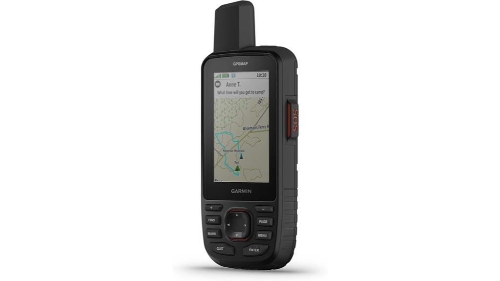
If you’re venturing into remote or rugged terrains where cell service is unreliable, the Garmin GPSMAP 67i stands out as an essential tool, thanks to its inReach satellite technology. It offers two-way messaging, interactive SOS, and detailed maps on a bright, 3-inch display. With multi-band GNSS support and preloaded TopoActive maps, it guarantees accurate navigation even in challenging environments. The device is built tough—waterproof, impact-resistant, and long-lasting—making it perfect for extended adventures. Paired with Garmin Explore, it provides weather updates, waypoint management, and satellite imagery, giving you peace of mind and precise navigation in the most remote locations.
Best For: outdoor enthusiasts, explorers, and adventurers who need reliable, rugged GPS navigation and satellite communication in remote or challenging environments.
Pros:
- Offers accurate multi-band GNSS and detailed preloaded maps for precise navigation in tough terrains
- Built tough, waterproof, and impact-resistant, suitable for extended outdoor activities
- Includes inReach satellite technology for global two-way messaging and emergency SOS, providing peace of mind in remote locations
Cons:
- Higher price point compared to basic handheld GPS units
- Features and interface have a learning curve, requiring familiarity for full utilization
- Satellite subscription required for inReach communication features, adding ongoing costs
A6 Handheld GPS for Hiking
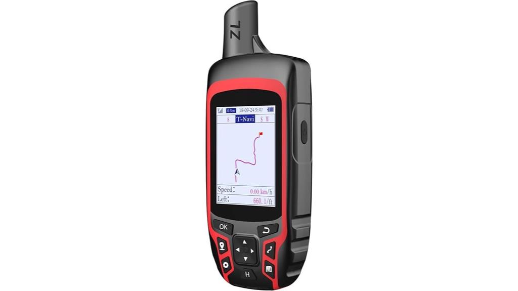
For outdoor enthusiasts who need reliable navigation in challenging terrains, the A6 Handheld GPS stands out with its support for four global satellite systems—GPS, GLONASS, BEIDOU, and QZSS—delivering high accuracy within five feet. Its 2.4-inch sunlight-readable color display remains visible even at night, and the button-operated, non-slip design makes it easy to handle. With capacity for 1,000 waypoints and features like route tracking and back navigation, it’s perfect for hiking, camping, or hunting. Rugged and waterproof (IP65), it’s lightweight at just 8 ounces. While it lacks map functions and some coordinate options, its durability and battery life—up to 20 hours—make it a solid choice.
Best For: outdoor enthusiasts like hikers, campers, and hunters who require high-accuracy navigation in challenging terrains with durable, reliable equipment.
Pros:
- Supports four satellite systems (GPS, GLONASS, BEIDOU, QZSS) for high-precision location tracking.
- Rugged, waterproof design (IP65) and lightweight, making it durable and portable for outdoor use.
- Long battery life of up to 20 hours, suitable for extended outdoor adventures.
Cons:
- Lacks map functionality and support for different coordinate formats like UTM.
- The menu system is somewhat limited and can be clumsy to navigate.
- The device produces loud beeping sounds on button presses, which may be annoying, though this can be mitigated by covering the speaker.
Garmin inReach SE+, Handheld Satellite Communicator with GPS Navigation
When safety and reliable communication are top priorities on outdoor adventures, the Garmin inReach SE+ stands out as an excellent choice. It’s a rugged, lightweight device with a clear, transflective color display and physical buttons, making navigation straightforward even in bright conditions. Equipped with global Iridium satellites, it allows two-way messaging and emergency SOS alerts from virtually anywhere. Its GPS features include route planning, waypoint management, and compatibility with external maps. With a battery lasting about a week and subscription plans supporting tracking and messaging, the inReach SE+ offers peace of mind and essential navigation for remote hikes.
Best For: outdoor enthusiasts and adventurers who need reliable satellite communication, GPS navigation, and emergency safety features in remote areas.
Pros:
- Global Iridium satellite coverage ensures communication almost anywhere on Earth.
- Rugged, lightweight design with a clear transflective display for easy reading in bright conditions.
- Comprehensive safety features including SOS alerts, weather forecasts, and location sharing.
Cons:
- Subscription plans can be costly, especially for high-frequency tracking and messaging.
- On-screen keyboard typing can be cumbersome, making quick messages challenging.
- Occasional GPS inaccuracies or skipped logs may occur during movement or stationary periods.
Bushnell BackTrack Mini GPS Navigation, Waterproof Portable GPS for Hiking and Hunting
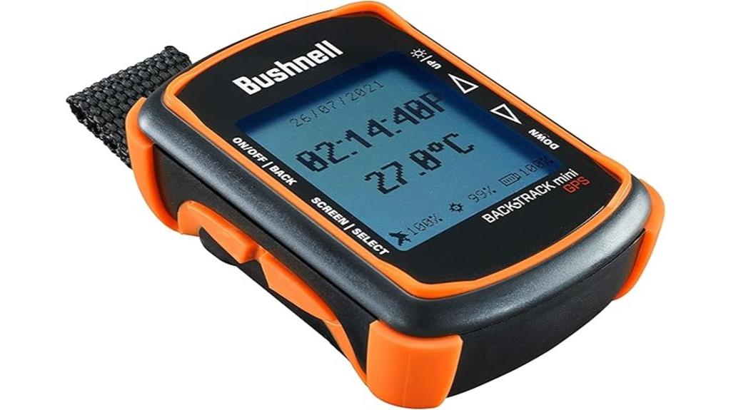
Looking for a reliable GPS device that can withstand tough outdoor conditions? The Bushnell BackTrack Mini is perfect for hiking and hunting. It captures trips and waypoints using GPS, helping you navigate back to trailheads or campsites. With features like elevation data, barometric pressure, and sunrise and moonrise times, it offers useful info for outdoor adventures. Its rugged, waterproof design and large, glove-friendly buttons make it durable and easy to operate in any weather. Plus, with a 35-hour battery life and Bluetooth connectivity to the Bushnell Connect app, you can store, share, and review your trips easily—ensuring you stay on track every time.
Best For: outdoor enthusiasts such as hikers and hunters who need a durable, reliable GPS device to navigate in remote areas without cellular coverage.
Pros:
- Rugged, waterproof design ensures durability in tough outdoor conditions.
- Long battery life of up to 35 hours supports extended adventures.
- Bluetooth connectivity allows easy sharing and review of trips via the Bushnell Connect app.
Cons:
- Limited advanced mapping features compared to full GPS navigation systems.
- Requires charging via Micro USB, which may be less convenient than modern charging options.
- The device’s small size may make it easy to misplace during strenuous activities.
Garmin Montana 700 Rugged GPS Handheld
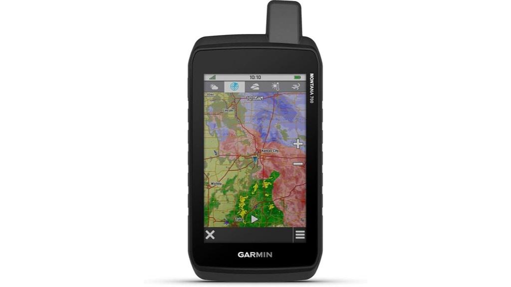
The Garmin Montana 700 Rugged GPS Handheld stands out for outdoor enthusiasts who need a durable and dependable device in challenging environments. Its rugged construction, rated MIL-STD 810, ensures it withstands thermal shifts, shocks, water, and vibrations. The bright 5-inch glove-friendly touchscreen makes navigation easy, even with gloves on. Supporting Multi-GNSS systems, it offers precise positioning on roads and trails. With preloaded TopoActive maps, barometric altimeter, and a 3-axis compass, it’s perfect for thorough navigation. Connectivity options like Wi-Fi, Bluetooth, and ANT+ allow quick data sharing and map downloads. It’s built to perform reliably in demanding outdoor conditions.
Best For: outdoor enthusiasts and professionals who require a rugged, reliable GPS device for navigation in challenging environmental conditions.
Pros:
- Rugged construction rated MIL-STD 810, ensuring durability against shocks, water, and vibrations
- Large 5-inch glove-friendly touchscreen for easy operation in various conditions
- Supports Multi-GNSS (GPS, GLONASS, Galileo) for accurate positioning on roads and trails
Cons:
- May be heavier and bulkier compared to more compact handheld GPS units
- Higher price point due to advanced features and rugged build
- Limited internal storage without additional microSD card support (if applicable)
Garmin GPSMAP 67i Rugged Hiking GPS Handheld with Satellite Technology

If you’re venturing into remote or rugged terrains where cell service is unreliable, the Garmin GPSMAP 67i stands out as an essential tool thanks to its inReach satellite technology. This rugged device meets military standards, so it can handle shock, water, and extreme temperatures. Its multi-band GNSS support guarantees precise positioning even in challenging environments. With a large sunlight-readable screen, built-in flashlight, and long-lasting 425-hour battery, it’s perfect for extended trips. The two-way messaging, interactive SOS, and Garmin Response coordination offer peace of mind. Plus, seamless integration with apps makes trip planning and communication simple, no matter how far off-grid you go.
Best For: outdoor enthusiasts and adventurers who need a rugged, reliable GPS with satellite communication for remote and challenging terrains.
Pros:
- Rugged construction meeting military standards for durability in harsh environments
- Extensive battery life of up to 425 hours, ideal for long trips
- InReach satellite technology offering two-way messaging, SOS, and location sharing in areas without cell coverage
Cons:
- Requires an active subscription for SOS and weather services, adding ongoing costs
- Slightly heavier and bulkier compared to standard handheld GPS devices
- Advanced features and satellite communication may have a learning curve for new users
Factors to Consider When Choosing a Handheld GPS for Hiking
When selecting a handheld GPS for hiking, I focus on factors like signal strength and accuracy to guarantee reliable navigation. I also consider battery life and how I can recharge or swap batteries on the trail, along with durability to withstand weather conditions. Finally, I look at map compatibility, ease of use, and how well the device suits my specific hiking needs.
Signal Strength and Accuracy
A strong GPS signal depends on having a clear view of the sky, free from obstructions like dense trees, mountains, or buildings that can block satellite signals. When the sky is open, signals are more reliable, improving accuracy. Many modern handheld GPS devices support multiple satellite systems—such as GPS, GLONASS, BEIDOU, Galileo, and QZSS—which boosts reliability and positional precision in difficult environments. Typically, these devices are accurate within 5 to 10 meters, but advanced models with multi-band GNSS support can achieve 1 to 3 meters, even in challenging terrains. However, factors like atmospheric conditions, satellite geometry, and whether the device has recent satellite lock influence signal quality. Ensuring a good satellite lock helps you stay accurate and avoid getting lost in tricky environments.
Battery Life and Charging Options
Choosing a handheld GPS for hiking requires careful attention to battery life and charging options, as these factors directly impact your device’s reliability during extended trips. Longer battery life ensures your GPS can last through full-day hikes or multi-day adventures, with some models offering up to 25 hours or more of continuous use. Rechargeable internal batteries, like Li-ion or Lithium Polymer, provide convenience and reduce waste compared to disposable batteries. Multiple charging options, including USB, wall adapters, power banks, and car chargers, give you flexibility to recharge in various outdoor settings. Keep in mind that cold weather can reduce battery performance, so look for devices with extended or expedition modes. Always carry spare batteries or a portable charger to avoid losing navigation capability when it matters most.
Durability and Weatherproofing
Battery life and charging options are essential, but guaranteeing your GPS can withstand tough outdoor conditions is equally important. A rugged device with an IPX4 or higher waterproof rating can handle rain, splashes, and splattering, keeping it functional in wet weather. Look for models with shock-resistant features, such as MIL-STD-810 certification, which protect against drops and bumps during rugged hikes. Sealed buttons and ports prevent dust, dirt, and moisture from entering, maintaining reliable operation in harsh environments. Reinforced bezels and impact-resistant screens are vital for surviving accidental impacts and rough terrain. Additionally, a GPS with long-lasting battery performance in extreme temperatures and effective power management ensures you stay on track no matter the weather or duration of your adventure. Durability is key to outdoor success.
Map Compatibility and Updates
When selecting a handheld GPS for hiking, ensuring that it supports the necessary map formats and update methods is essential for reliable navigation. I look for devices that support common formats like GPX, TCX, or proprietary files, making it easier to transfer and customize maps. It’s also important that the device allows for straightforward map updates via software or firmware downloads, so maps stay current with recent trail changes or new routes. I prefer GPS units that support downloadable or preloaded topographical, trail, or satellite imagery maps for added detail. Additionally, supporting external or custom map sources can be a game-changer for specialized activities. Finally, I check how often updates are released and whether they’re free or require additional purchases, ensuring continuous access to fresh, accurate maps.
User Interface and Ease
A user-friendly interface is essential for maneuvering a handheld GPS efficiently, especially in challenging outdoor conditions. An intuitive design with clear menus and straightforward navigation makes it easier to operate the device quickly, even under stress. Physical buttons should be responsive and logically arranged, so I can use them confidently with gloves or in wet weather. A high-contrast, readable display is crucial for quick access to vital information in bright sunlight. Simplified workflows for tasks like saving waypoints, plotting routes, and viewing tracks help me stay focused without confusion. Consistent audible feedback and logical menu hierarchies create a smoother experience, reducing frustration when I need to make quick decisions. Overall, a well-designed interface keeps me on track and enhances my outdoor adventures.
Group Connectivity Features
Group connectivity features expand the capabilities of handheld GPS devices beyond solo navigation, allowing me to stay linked with my hiking companions. With these features, I can share my location, send preset messages, and coordinate in real-time, which boosts safety and teamwork. Devices supporting group connectivity often create private, closed networks that work over several miles, ensuring reliable communication even in remote areas. Compatibility is key; I look for units that use Bluetooth, radio, or satellite links for consistent data exchange. Some GPS units let me manage groups, share waypoints, and track updates instantly, so everyone stays informed. Overall, these features help prevent straying off course, facilitate quick emergency responses, and make group hikes safer and more enjoyable.
Size and Weight Considerations
Choosing the right handheld GPS for hiking involves carefully weighing size and weight, as these factors directly impact comfort and convenience on the trail. A lightweight device under 8 ounces is easier to carry during long hikes and reduces fatigue. Compact units around 6 inches or less are less cumbersome and fit comfortably in a pocket or backpack pocket. However, larger, heavier GPS units can cause discomfort over extended use and may require extra support or carrying accessories. Smaller devices often have smaller screens, which can make reading maps and orienteering outdoors more challenging. Finding a balance between size and weight is vital to guarantee the GPS remains portable without sacrificing essential features. The goal is to pick a device that’s lightweight but still easy to use and read in outdoor conditions.
Frequently Asked Questions
How Do Handheld GPS Devices Improve Safety During Hikes?
Handheld GPS devices substantially boost safety on hikes by providing accurate location tracking, even in remote areas without cell service. I rely on them to follow trail routes, avoid getting lost, and mark important waypoints like water sources or emergency exits. They help me stay oriented, monitor my progress, and quickly share my location if needed. With a GPS, I feel more confident and prepared to handle unexpected challenges on the trail.
Can These GPS Units Track Real-Time Weather Conditions?
Imagine having a weather wizard in your pocket—that’s what some handheld GPS units offer. While many focus on navigation, some models now include real-time weather tracking, giving you updates on storms or temperature changes. I’ve found these features invaluable on rugged trails, helping me stay ahead of weather shifts and plan my next move. Not all units have this, so check the specs if weather alerts are a priority for your adventures.
What Is the Battery Life Range for Extended Hiking Trips?
You’re wondering about battery life for extended hikes. I’ve found that most high-quality handheld GPS devices last between 16 to 24 hours on a single charge, which is usually enough for a full day of trekking. If you’re planning multi-day trips, consider models with replaceable batteries or portable power banks. I always carry spares just in case, ensuring I stay connected and on track no matter how long I hike.
Are These GPS Devices Compatible With Smartphone Apps?
You’re wondering if these GPS devices work with smartphone apps, right? Many of the top models are indeed compatible, allowing you to sync data, plan routes, and access maps via dedicated apps. I find this feature incredibly useful because it keeps everything connected and easy to update. Just make sure to check each device’s specifications, as compatibility can vary. It’s a great way to enhance your hiking experience.
How Do Rugged GPS Models Handle Extreme Environmental Conditions?
When it comes to rugged GPS models, I’ve found they handle extreme environments pretty well. They’re built tough with durable materials, so they resist water, dust, and shocks. I’ve tested some in heavy rain and rugged terrains, and they keep working smoothly. These devices often have sealed cases and reinforced screens, ensuring they stay reliable no matter the weather or conditions I encounter.
Conclusion
No matter which GPS you choose, think of it as your trusty compass guiding you through the wilderness. With the right device in hand, you’ll stay on track like a ship steering through calm seas, enthusiastic to explore more and worry less. These gadgets are your ticket to safer, more confident adventures. So, gear up with the best handheld GPS, and let your hiking journey unfold like a story worth telling.